
Most travel content about New Zealand hits the same notes. Milford Sound gets its paragraph. Rotorua’s geysers get theirs. Waitomo Caves show up on cue. And then the article ends, the checklist complete, the actual country barely scratched.
The problem isn’t that these places are overrated — they’re genuinely extraordinary. The problem is that New Zealand’s geological story runs far deeper than any top-ten list suggests. This is a country sitting on the boundary of two tectonic plates, with a landmass that was almost entirely submerged under shallow seas for millions of years. The result is a landscape that’s been folded, erupted, dissolved, uplifted, and carved by glaciers — and much of the evidence is lying in plain sight, barely visited, rarely written about. Pair your visit with a look at Weird Wildlife & Flora — From Glowworms to Giant Crickets to discover unusual species and unique ecosystems.
What follows is a guide to the geological marvels that most travel blogs skip entirely.
The Ōpārara Basin — A Lost World Nobody Talks About
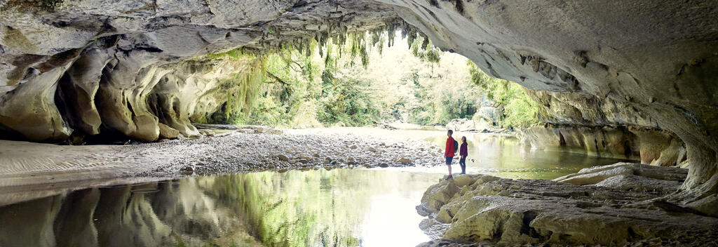
Just north of Karamea, on the northern extremity of the South Island’s west coast highway, the magnificent Ōpārara river basin offers explorers a ‘lost world’ experience. The basin is one of the finest features of the Kahurangi National Park. For a million years the Ōpārara river system has been sculpting the 35 million-year-old limestone into an intriguing complex of caves, arches and channels.
Those numbers deserve a moment. The limestone is 35 million years old. The river has been carving through it for a million years. And the result, hidden behind a narrow gravel road north of one of New Zealand’s most remote towns, is something competitors in this space consistently underreport.
The Ōpārara Arch is 219 metres long and 79 metres wide, with a roof rising 43 metres above the river. It is the largest natural rock arch in the Southern Hemisphere. A local legend holds that someone once flew a small plane through it — almost certainly untrue, but the fact that the story circulates at all tells you something about the scale of the thing.
The Ōpārara Basin resides on a foundation of 350 million year old granite, which was covered with a 15–60m thin layer of limestone approximately 35 million years ago. That ancient granite is the bedrock of the whole spectacle. The limestone layer has been extensively eroded by annual rainfall of up to 6 metres and the roots of the lush vegetation. This is a place where the plants themselves are actively dismantling the geology.
Then there’s the second arch — the Moria Gate. Moria Gate Arch is 19 metres high and 43 metres wide, and its ceiling is extensively covered with stalactites and roots. Its Lord of the Rings–inspired name fits perfectly: walking into it feels like stepping into a different era. The cave floor is sandy, the river threads through it quietly, and the ceiling disappears into shadow above.
What makes the basin genuinely unlike anywhere else is what’s hidden inside the Honeycomb Hill cave system. The Honeycomb Hill Cave area was discovered in 1976 and in 1982 was given the status of a site of global significance in paleozoology due to discoveries of bones of several species that had gone extinct upon human settlement. More than 50 bird species, many of them extinct, have been recorded. These include nine different moa species, the giant flightless goose, and the giant New Zealand eagle. The cave is accessible only by guided tour, and the bones inside — perfectly preserved by the limestone’s chemistry — are as close to a time capsule as geology gets.
Getting here requires commitment: a narrow gravel road, no campervans, and an honest awareness that you’re a long way from anything. That’s exactly the point.
The Pancake Rocks — Famous, But Nobody Explains Why They Exist
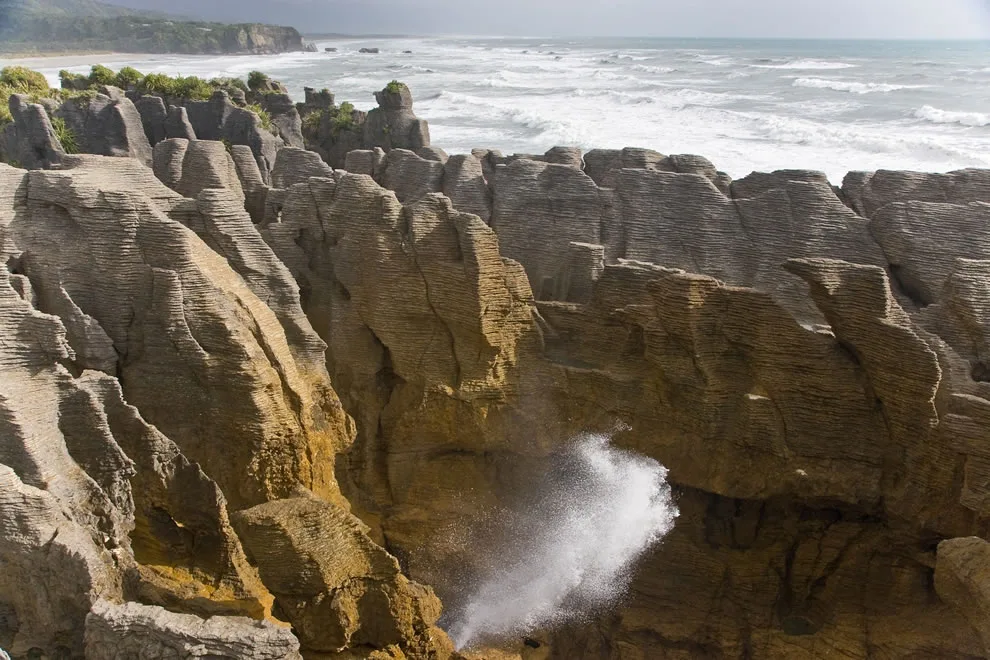
The Pancake Rocks at Punakaiki appear in almost every New Zealand travel guide. What those guides almost never do is explain what you’re actually looking at — which is a shame, because the geological story is more interesting than the photographs.
The limestone was formed in the Oligocene period, around 22–30 million years old, a period in the geological history of New Zealand where most of the continent of Zealandia was submerged beneath shallow seas. At that time, there was no West Coast as we know it. The Southern Alps hadn’t been built yet. The land that would become New Zealand was mostly ocean floor, covered in warm shallow water teeming with marine life.
When these animals died, their shells settled on the sea floor along with small amounts of sand and mud eroded from nearby islands. Over millions of years, vast quantities of shell debris accumulated on the sea floor, eventually forming a thick deposit of nearly pure calcium carbonate. Then the tectonic plates shifted, the Alps began to rise, and the seafloor was gradually pushed upward toward daylight.
The distinctive stacked appearance — the reason they’re called Pancake Rocks — comes from a process called stylobedding. Although the origin of stylobedding has been debated, it is mostly agreed that this layering is not original bedding, but a secondary feature caused by compaction. The imperfections in the rock and crystal lattice can migrate under pressure through a process called grain boundary diffusion, aligning in a plane and making it weaker. Since the weaker bands are made up of fine, weakly-bonded clay minerals, they erode faster than the stronger limestone, forming the ‘pancakes’.
In short: the layers you see are the result of differential erosion between hard and soft bands — a process that’s been going on for roughly 100,000 years. The blowholes came later, as sea caves formed and their roofs collapsed, leaving vertical shafts through which incoming swells blast upward with considerable force.
The Putai Blowhole spouts spectacularly at high tide and during a south-westerly swell. Timing your visit around the tides isn’t optional — it’s what separates a pleasant walk from something you remember for years.
The name Punakāiki is itself a Māori phonetic representation of the word ‘pancakes’ which means the rocks have been making an impression on people since long before Europeans arrived.
The Moeraki Boulders — Spheres That Took Five Million Years to Form
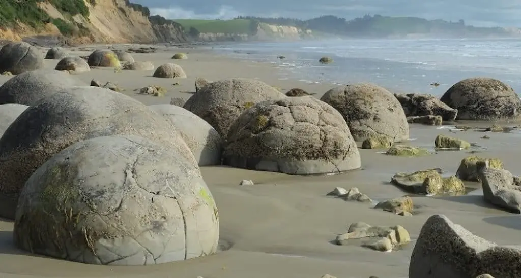
On a stretch of Koekohe Beach in North Otago, grey spherical boulders emerge from eroding mudstone cliffs and roll down onto the sand below. The Moeraki Boulders are concretions created by the cementation of the Paleocene mudstone of the Moeraki Formation, from which they have been exhumed by coastal erosion.
That word — exhumed — is exactly right. The boulders have been buried for tens of millions of years. The cliffs are gradually being eaten by the sea, and each new boulder exposed is rolling out onto the beach for the first time since it finished forming roughly 60 million years ago.
The largest boulders are thought to have taken more than four million years to form. That’s an almost incomprehensible length of time for something that looks, from a distance, like a garden ornament. The process is similar to the way a natural pearl forms around a foreign particle within an oyster — minerals cementing particles together in concentric layers, growing slowly over millions of years. Each boulder began with a tiny organic nucleus — a shell fragment, a leaf, a fish bone — and grew outward as calcium carbonate precipitated from surrounding seawater.
About 15 million years ago the Moeraki Formation was lifted above sea level, where breaking waves began to wear it down. The erosion that’s revealing the boulders today is the final act of a geological story that started on an ancient seafloor.
The Māori account of the boulders is equally compelling. According to Māori legend, the origin of the boulders dates from the loss of the Āraiteuru, one of the large sailing canoes that came from distant Hawaiki. On her quest south for the precious greenstone, the canoe was wrecked near Shag Point. The reef which extends seawards is the canoe’s petrified hull, while strewn along the beach are boulders representing the eel baskets, calabashes, and kūmara washed ashore from the wreck.
Both explanations — the geological and the ancestral — are stories about long journeys that ended on this beach. The boulders don’t particularly care which version you prefer.
Visit at sunrise or low tide for the best light. The boulders are partially submerged at high tide and the soft morning light catches the calcite patterns in the cracked ones in a way that afternoon sun simply doesn’t replicate.
The Pink and White Terraces — The Wonder That Was Lost
Not every geological marvel can be visited. Some have been erased entirely — and the story of their disappearance is worth telling.
The Pink and White Terraces were reportedly the largest silica sinter deposits on Earth. They were formed by hot silica-rich water flowing down the hillside beside Lake Rotomahana and cooling as it went, depositing layer upon layer of white silica into a series of enormous natural terraced pools. The Pink Terraces descended to the lake’s edge in a cascade of shallow, warm, brilliantly coloured pools. The White Terraces were larger — covering roughly 8 hectares, descending some 25 metres in elevation. By the late 19th century they had become New Zealand’s most visited natural attraction, sometimes called the Eighth Wonder of the World.
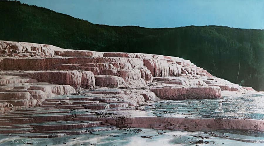
On 10 June 1886, Mount Tarawera erupted. The eruption spread from west of Wahanga dome down to Lake Rotomahana. The volcano belched out hot mud, red hot boulders, and immense clouds of black ash from a 17 kilometre rift that crossed the mountain, passed through the lake, and extended beyond into the Waimangu valley.
The terraces were buried completely. The lake that had formed beside them was obliterated and replaced by a new, much larger Lake Rotomahana. For over a century, the terraces were considered gone permanently. Then, in 2011, a research team scanning the lake bed with sonar found fragments of both terraces buried under the sediment — damaged, but not entirely destroyed. Whether they will ever be accessible again is an open question. For now, they remain the most spectacular geological loss in New Zealand’s recorded history.
What New Zealand’s Geology Is Actually Telling You
Most of the sites above have something in common that travel writing tends to ignore: they are not just pretty. They are evidence of a specific geological narrative — the story of Zealandia, the sunken continent.
New Zealand is a geologically active country, with numerous geothermal features found nowhere else. The country’s location on the Pacific Ring of Fire, where tectonic plates collide, results in high levels of geothermal activity. But the deeper story is older than the Ring of Fire. Zealandia — the submerged landmass of which New Zealand is the visible tip — separated from Gondwana roughly 85 million years ago. It sank almost entirely beneath the sea. The limestone of the Pancake Rocks, the mudstone of the Moeraki Formation, the granite foundation of the Ōpārara Basin — all of these formed during that long submersion, when the land was a seafloor.
The New Zealand you’re standing on today is a geological comeback story. And the marvels described in this article are the physical evidence left behind by each chapter of that story — boulders that grew in ancient seawater, rock arches dissolved by a million years of rain, terraces built grain by grain by cooling geothermal water, and pancake-layered cliffs assembled from the shells of creatures that lived before mammals walked the earth.
Most visitors get a week. That’s enough to see what’s on the surface. The geology, if you’re paying attention, goes considerably further down.